Date:
20.03.2024 17:00
A contribution by
laughingsquid.com
com/wp-content/uploads/2024/03/Literal-Translation-of-City-and-State-Names.jpg?w=750" srcset="https://laughingsquid.com/wp-content/uploads/2024/03/Literal-Translation-of-City-and-State-Names.jpg 1280w, https://laughingsquid.com/wp-content/uploads/2024/03/Literal-Translation-of-City-and-State-Names.jpg?resize=300,296 300w, https://laughingsquid.com/wp-content/uploads/2024/03/Literal-Translation-of-City-and-State-Names.jpg?resize=768,758 768w, https://laughingsquid.com/wp-content/uploads/2024/03/Literal-Translation-of-City-and-State-Names.jpg?resize=750,741 750w" sizes="(max-width: 1280px) 100vw, 1280px" />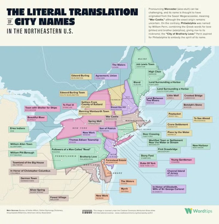 tips/literal-translations-us-cities-states/">
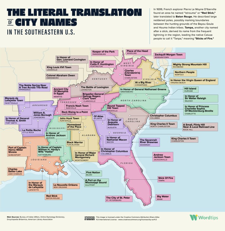 tips/literal-translations-us-cities-states/">
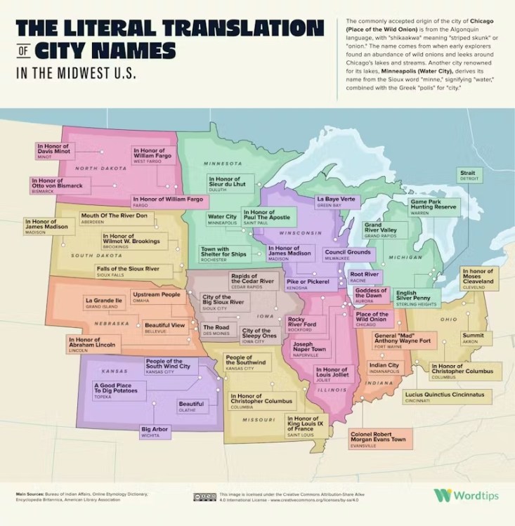 tips/literal-translations-us-cities-states/">
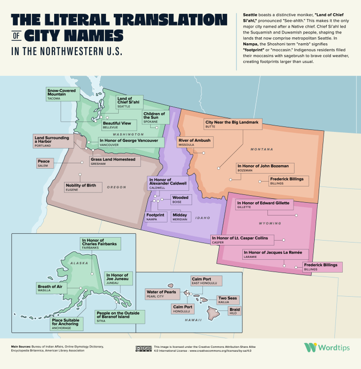 tips/literal-translations-us-cities-states/">
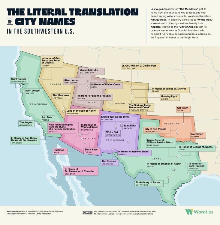
The folks at WordTips compiled an interesting set of data that plots the literal meaning of US state and city names on maps of each quadrant of the country; the Northeast, the Southeast, the Midwest, the Northwest, and the Southwest.
To know the meaning of the place names around us is to learn how the land, the history and the culture of a locality have developed over the centuries.
While RobWords previously explained the origins behind state names, these maps go into a bit more detail regarding specific locations using public sources.
tips/literal-translations-us-cities-states/">Researchers at WordTips trawled a variety of sources, including the Bureau of Indian Affairs, the Online Etymology Dictionary, the Encyclopedia Britannica, the American Library Association and regional news reports to uncover the literal meaning behind the name of each U.S. state, each U.S. state’s capital city and 178 of America’s biggest cities.
tips/literal-translations-us-cities-states/">tips/literal-translations-us-cities-states/">tips/literal-translations-us-cities-states/">tips/literal-translations-us-cities-states/">Latest Posts

09.04.2024 17:37
Ethereum ETFs: Will the SEC Give Them the Go-Ahead?
The launch of 11 spot bitcoin exchange-traded funds (ETFs) in January proved to be immensely popular with investors. Thus far, … Read more
Read more 
10.04.2024 14:02
Movies are Back: Cinemark Stock Could Have a Blockbuster Summer
With the start of blockbuster movie season, movie theater and cinema companies are hoping for the next so-called “Barbenheimer” to … Read more
Read more 
11.04.2024 09:00
Illdisposed: gehen auf Europatournee mit Defacing God als Support
Die dänischen Death-Metal-Veteranen Illdisposed gehen im September 2024 auf Europatournee, nachdem sie ihr 16
Read more 
16.03.2024 15:00
Revitalizing Spiritual Music with Divine Echoes – Fratena Presents “Glory of God”, A Symphony of Creation’s Praise
Inspirational Worship Leader and Singer/Songwriter Fratena invites audiences to revel in her symphonies and divine praises as she continues to ink a stunning presence in the music world Chico, CA —In the realm of spiritual music, where voices echo the divine, Fratena stands out with her harmonious tribute to the Almighty in her newest single, […]
Read more 
26.03.2024 12:06
How Much Does it Cost to Develop an eWallet Application?
Discover the factors influencing eWallet app development costs and make informed decisions for your project. Get insights now!
Read more 
16.03.2024 19:30
Spectacular Winning Portrait Photos From The Monochrome Photography Awards
1st Place Winner: Acid Attac Survivor By Erico Hiller These amazing portrait photographers won the 2023 Monochrome Photography Awards
Read more
Comments